
CLANTON – Monday, 6:00 am, April 27, 2026
An area of thunderstorms with heavy rainfall will move into the far northern portions of the state around 12 am tonight and continue southward into Tuesday morning, weakening once reaching I-20. A few wind gusts from 40-60 mph and very heavy rainfall are possible north of I-20.
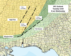
Redevelopment of thunderstorms is possible across the southern half of the state on Tuesday afternoon, and a few storms may produce wind gusts from 40-50 mph. However, the bigger threat of severe weather is Tuesday evening into early Wednesday.
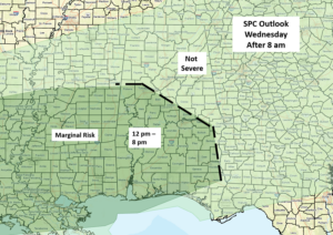
A cluster of strong to severe storms will move into northwestern Alabama Tuesday evening, then move southeastward overnight, likely dropping below severe levels once it reaches I-20 by early morning Wednesday. However, re-strengthening is possible on Wednesday afternoon, south of I-20. Damaging straight-line wind gusts are the main threat Tuesday into Wednesday, although a tornado or two cannot be ruled out. However, the overall tornado threat is currently low.
Although not continuous, additional upper-level systems may bring periods of heavy rainfall and some potential for severe weather from Thursday through the weekend over the southern half of Alabama. However, the overall severe threat is low at this time.
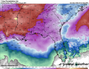
Total rainfall amounts through Sunday evening will be 2-3 inches across the northern half of the state, with 1-3 inches over the southern half. As always, locally higher amounts will occur with stronger storms. Beneficial rainfall will occur, but flooding may become an issue in some areas.


