
CLANTON – Wednesday, 6:00 am, May 6, 2026
It now appears that supercells will move into the western portions of the state this afternoon and form a broken to solid line by early evening somewhere near the I-20 corridor. Unfortunately, the line is forecast to slow its southward progress and not exit the southern portions of the state until mid to late Thursday morning.
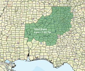
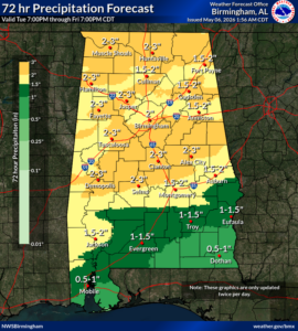
Very heavy rainfall, damaging wind gusts, hail, and a few tornadoes are all possible. Widespread 1-3 inches of total rainfall will occur, with areas of 5+ inches possible, resulting in some flooding. The NWS has issued a Flood Watch for most of central Alabama. In addition, if supercells can maintain themselves, a few strong tornadoes are possible.
It’s been quite some time since we’ve had severe weather potential like this. Now is the time to review your severe weather plan or develop one if you haven’t yet. Go to ready.gov/plan for more information.
Also, as described in the link above, make sure you have at least two methods to alert you of warnings, wake you up in the middle of the night, and one of which is NOT an outdoor siren.
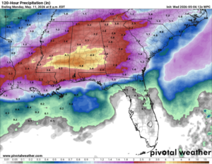
Finally, although not continuous, additional upper-level systems will produce rainfall across portions of the state from Friday evening through Sunday. Total precipitation from today through Sunday will be widespread 3-5 inches, and possibly 8+ inches in spots. Additional Flood Watches may be needed this weekend.


