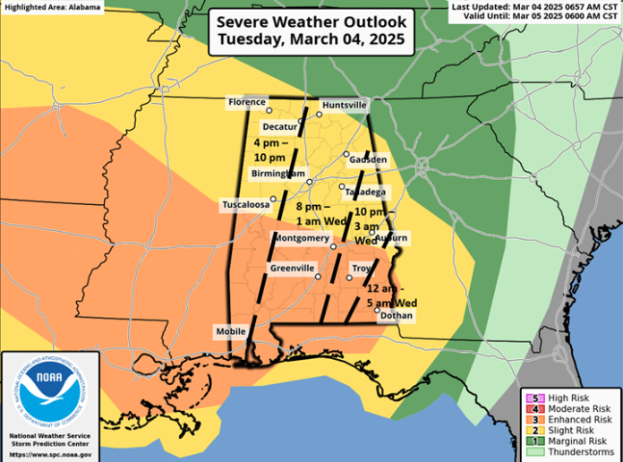
CLANTON – Strong and gusty winds have knocked down trees and power lines in parts of Central Alabama this afternoon. Winds will continue to be sustained at 15-25 mph with frequent gusts from 30-40 mph, and a few gusts as high as 45 mph. A statewide Wind Advisory is in effect.
If you have any light-weight, loose outdoor objects, consider bringing them inside or securing them.
A line of showers and thunderstorms will enter western Alabama between 5-7 pm, race eastward and exit the southeastern portions by 3 am Wednesday.
Damaging wind gusts and a few embedded tornadoes are possible. The highest potential for more intense wind and tornado damage is in the Enhanced Risk area across the southern half of the state, including the potential for a couple of EF2+ tornadoes and widespread straight-line wind damage.
Since the actual line of storms will be moving at 40-60 mph, momentum winds reaching the surface could produce pockets of damage even across the Slight Risk area.
Behind the line, gusty winds will continue between 20-30 mph from early Wednesday morning through early Thursday morning, with a few gusts up to 35 mph Wednesday morning and afternoon.
Now is the time to make sure you have a severe weather plan and can receive warnings from at least two reliable sources (one of which is NOT an outdoor warning siren). More information on developing a severe weather plan can be found at ready.gov/severe-weather
Make sure you cell phone has the Wireless Emergency Alerts (WEA) turned “on”. Most NWS Severe Thunderstorm Warning DO NOT trigger WEA, and folks are surprised to receive damage and no alert. That’s why it’s important to have at least two methods to receive warnings.


