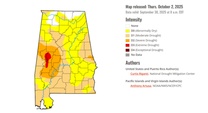
Soil conditions continue to worsen. Much of the state is now in a Moderate to Severe Drought with Extreme Drought in the western sections. Although some precipitation is forecast during the next week, especially near the coast, no widespread, significant rainfall is expected for the next seven days.

The Alabama Forestry Commission has issued a Statewide Fire Danger Advisory until further notice. Refrain from doing any burning and never leave a fire until it is extinguished. Always obtain a permit for prescribed burns, and ensure adequate equipment and personnel are present.
Without tropical activity affecting the state, October is typically the driest month of the year with statewide normal amounts between 3-4 inches.
October Monthly Normals
Huntsville – 3.56
Birmingham – 3.34
Montgomery – 2.87
Mobile – 3.95
Concerning the tropics, an area of low pressure has formed near the Bahamas and is expected to meander near Florida and the Bahamas for the next several days. Strong upper-level winds are expected to prevent significant development, and there remains only a 10% chance that tropical development will occur.
However, this will produce a tight pressure gradient from the Louisiana to Florida coasts. A High Surf Advisory and High Rip Current risk is in effect for Mobile and Baldwin County beaches, with a Small Craft Advisory out to 70 miles offshore through the afternoon of October 5.
Finally, a tropical wave will move off the African coast today, interact with another disturbance in the Atlantic, and then move westward. There is currently a 40% chance of tropical development.


