
CLANTON, Ala. – Thursday, 7:30 a.m., June 11, 2026
After a dry day today, scattered thunderstorms are forecast to develop north of I-20 tomorrow afternoon and evening. Very heavy rainfall and a few wind gusts from 40-60 mph are possible.
Scattered to numerous showers and thunderstorms are forecast statewide from Saturday through at least next Wednesday. Especially by Sunday and continuing through the middle of next week, very heavy rainfall is expected, and a few storms each day could produce wind gusts from 40-60 mph.
Although not continuous, total rainfall across the state through next Wednesday will generally be between 2 and 5 inches, and some locations could easily have double these amounts. Flood Watches may be needed this weekend or early next week.
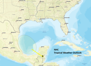
Finally, a broad area of low pressure will likely form over the Bay of Campeche on Friday and move northwestward into the western Gulf. There is a 10% chance of development before the system moves into Mexico late Saturday or Sunday. No impacts will occur in Alabama.


