Photo courtesy of pixabay
CULLMAN, Ala. – Ahead of this week's expected rainfall totals and flooding, the Cullman County Emergency Management Agency (CCEMA) is monitoring the situation closely, posting updates to social media to let citizens know what to expect.
Said CCEMA Director Phyllis Little, "We are posting the updated information to social media as soon as we get it so that the community is aware. This should give those in areas that have experienced flooding in the past time to prepare. We are also in contact with local response agencies to provide as much information as possible."
She continued, "Rainfall amounts expected are very similar to what we received in December 2015. All residents need to stay aware and be prepared to take action if needed. Flood safety tips are available at www.ready.gov/floods. We also have a 'Preparedness' tab on the Cullman EMA smartphone app that contains tips for all hazards including flooding. There is also a 'Social Media' tab on the app to make it easier for folks to keep up with CCEMA posts.
Here's the latest from the U.S. National Weather Service in Huntsville (This is being constantly updated. Click here.):
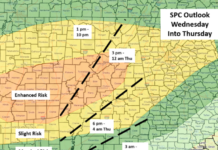
Heavy rain and flooding likely this week… A wet pattern will set up across the Tennessee Valley for much of the week, with several rounds of heavy rainfall affecting Northern Alabama and portions of Southern Middle Tennessee beginning late Monday. Throughout the week ahead, a frontal boundary will stall across the area, though there is still some uncertainty as to exactly where this feature will end up. The heaviest rainfall axis is expected to be along this stalled frontal boundary, where anywhere between 7 to 10 inches of rainfall are forecast. Isolated higher amounts are possible. While rainfall is literally forecasted for every day next week, the greatest potential for heavy rainfall and flooding will be from late Tuesday through at least Thursday, if not lingering into Friday. Given the wet ground conditions in place from recent rainfall, much of this expected 7 to 10 inches of rainfall will immediately convert to runoff. This will overwhelm the natural drainage processes, leading to flash flooding potentially at the onset of the heavy rain, and later in the week, widespread river flooding. Again, while there is still some uncertainty in exactly where the front will stall, nearly all of the river gages on the Tennessee River (and those on tributaries that feed into the Tennessee River) will likely reach flood stage at some point this week. The question will be how many will reach Moderate Stage (or higher). Lingering flooding on the Tennessee River will begin late this week, and will likely linger into the following week as well. Residents across Northern Alabama and Southern Middle Tennessee should continue to monitor this unfolding weather situation over the holiday weekend and stay tuned to further forecast updates from NWS Huntsville!
Hazardous Weather Outlook National Weather Service Huntsville AL
Lauderdale-Colbert-Franklin AL-Lawrence-Limestone-Madison-Morgan- Marshall-Jackson-DeKalb-Cullman-Moore-Lincoln-Franklin TN- This Hazardous Weather Outlook is for north Alabama and portions of southern middle Tennessee. .
DAY ONE…This Afternoon and Tonight. Isolated thunderstorms are possible this afternoon amongst numerous to widespread showers. Locally heavy rainfall of 1 to 1.5 inches is possible, mainly east of I-65.
DAYS TWO THROUGH SEVEN…Monday through Saturday. A significant risk of heavy rain and flooding is setting up for the middle to latter part of the week. Multiple periods of showers and a few thunderstorms are expected from Tuesday through Saturday. During this period, the heaviest rain may fall on Wednesday night into Thursday and again on Friday into Saturday. Rainfall totals through the week will reach above 5 inches at most locations, with up to 10 inches possible in a few areas. Should this persistent heavy rainfall materialize this week, potentially significant flash flooding and river flooding is expected.
RESOURCES FOR CITIZENS:
- www.facebook.com/CullmanCountyEMA/
- www.CullmanEMA.org
- www.twitter.com/CullmanEMA
- www.weather.gov/huntsville
- www.facebook.com/NWSHuntsville/
- www.twitter.com/NWSHuntsville
- www.twitter.com/simpsonwhnt
- www.twitter.com/JerryWVTM13
Copyright 2019 Humble Roots, LLC. All Rights Reserved.


