Heat Advisory Today with a Few Damaging Wind Gusts Possible
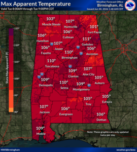
CLANTON – Tuesday, 7:00 am, June 30, 2026
High temperatures today through Saturday will be mainly in the middle 90s, except for the upper 90s today in parts of central Alabama, including the Birmingham metro area. Overnight low temperatures statewide will be in the middle 70s.
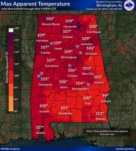
Afternoon Heat Index values will be 100-109 each day, and possibly as high as 111 in parts of central Alabama today. Heat Advisories will likely be expanded in time for portions of the state in later forecasts.
Heat buildup from successive hot days and very warm nights increases the risk of heat illnesses for those without air conditioning.
Drink plenty of fluids, stay in an air-conditioned room, stay out of the sun, and check up on relatives and neighbors. Children and pets should NEVER be left unattended in vehicles under any circumstances.
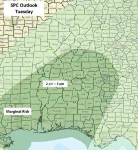
Although only isolated to scattered thunderstorms are expected this afternoon, because the atmosphere is very unstable, any storm that develops has the potential for wind gusts from 40-60 mph, generally south of I-20 this afternoon and evening. However, widespread severe storms will not occur.
Isolated to scattered thunderstorms are forecast mainly north of I-20 from Wednesday through Friday during the afternoon and evening hours. Once again, a few wind gusts from 40-60 mph are possible each day.
On Saturday, scattered showers and thunderstorms are forecast statewide, and from Sunday into early next week, a shift in the pattern will produce scattered to numerous showers and thunderstorms.
Finally, a broad area of low pressure off the South Carolina coast will continue to move southward, then westward later this week. There is only a 10% chance of tropical development, and conditions remain unfavorable for strengthening.


