
CLANTON – Sunday, 8:30 am, June 21, 2026
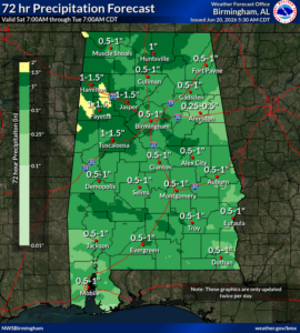
Today, scattered to numerous showers and thunderstorms are forecast mainly across the southern half of the state. Rainfall will generally be around 1 inch, but some spots could receive 2-4 inches, resulting in localized flooding. Damaging wind gusts are not expected.
Little to no rainfall will occur tonight through Monday morning. During the afternoon (and for the remainder of the week), we will be in a northwest flow aloft, with periodic clusters of storms (Mesoscale Convective Systems) moving from northwest to southeast across the state each day.
The timing for Monday’s activity is shown below. A few damaging wind gusts up to 60 mph, and heavy rainfall that may produce localized flooding are the threats.
There will be breaks in the precipitation each day, allowing any flooding to subside. However, due to saturated soils this week, it won’t take as much rainfall to produce additional flooding. Finally, the timing for each cluster of storms after Monday is highly uncertain, both in timing and specific locations.


