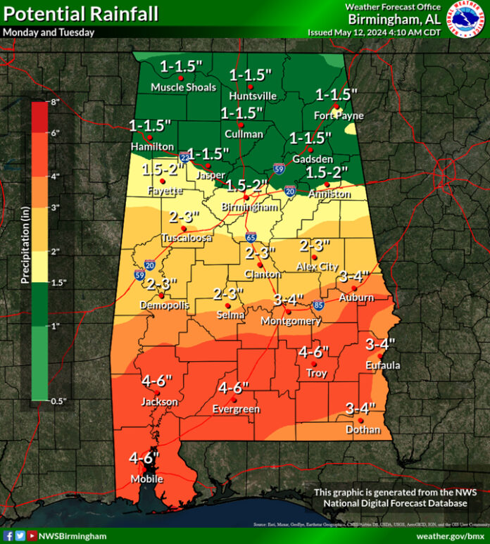
CLANTON, Ala. — Several upper-level disturbances will affect the state this week. The first will produce rain and thunderstorms beginning this evening in the western sections of the state and spreading eastward across most areas Monday into Tuesday.
The highest threat will be flooding rainfall, with widespread 3-6 inches across the southern half of Alabama by Tuesday night and locally higher amounts. The severe wind and potential tornado threat is much more uncertain and highly dependent upon the location of a warm frontal boundary on Monday.
The frontal boundary may stay just offshore until Monday evening, which would limit any severe threat. However, if the boundary moves farther inland (into central AL by afternoon), then a few damaging wind gusts and a couple of tornadoes would be possible near and south of the boundary Monday afternoon through the night. As such, the SPC has much of the state in a Marginal Risk Monday into early Tuesday, but the actual threat may end up much farther south.

Another wave of thunderstorms will move from west to east across the state early Tuesday and exit the eastern portions Tuesday afternoon. A few wind gusts from 40-60 mph and a couple of tornadoes will be possible.

After a mainly dry Wednesday through Thursday afternoon, showers and thunderstorms will spread across the state Thursday night through much of Friday. Flooding rainfall and a few damaging wind gusts are the main threats, especially Friday afternoon.
Total rainfall amounts from Monday through next Saturday morning will be widespread 2-5 inches across the northern half of AL with 5-9 inches and locally higher amounts across the southern half.
Expect changes to rainfall totals, severe weather risk areas and timing in later updates so keep up to date with the forecasts this week.


