CLANTON, Ala. – The active spring severe weather pattern continues across the southeast U.S. The National Weather Service (NWS) has confirmed 24 tornadoes from last Wednesday’s event, which was very significant, since this was more than half the number of tornadoes that typically occur statewide in an entire year.
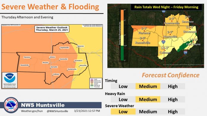
Unfortunately, another round of severe storms is likely Thursday afternoon until very early Friday morning. Don’t fall into the trap of wondering if Thursday’s event will be similar to last Wednesday’s. Like hurricanes, severe weather events are all different.
Focus on the fact that severe weather is likely, especially north of the Livingston – Montgomery – Auburn line.
Although a couple of storms could produce wind gusts of 40-60 mph Thursday north of I-20 between 8 a.m.–noon, the main threats will occur after noon, lasting until around 2 a.m. in the southeast part of the state.
Individual supercells are expected to form in the moderate and enhanced risk areas after 1 p.m., followed by a broken line of severe thunderstorms entering the western portions of the state after 4 p.m. This includes the potential for strong, long-track tornadoes.
As the line progresses both eastward and southward, it will lose intensity as the upper-level support pulls away from Alabama. All severe weather should be over by 2 a.m. Friday.
As far as rainfall, the highest amounts through Friday morning will be 2-4 inches with some spots nearing 6 inches in the southwest part of the state, with 1-3 inches across the northern half of the state. Some localized flash flooding may occur.
The unsettled pattern continues over the weekend, with a few strong storms possible both Saturday and Sunday. However, confidence in severe weather remains low at this point.
When a warning is issued, if you can safely get to a sturdy building, then do so immediately.
- Go to a safe room, basement or storm cellar.
- If you are in a building with no basement, then get to a small interior room on the lowest level.
- Stay away from windows, doors and outside walls.
- Do not get under an overpass or bridge. You’re safer in a low, flat location.
- Watch out for flying debris that can cause injury or death. Use your arms to protect your head and neck. You need helmets for everyone, including adults, as many injuries and deaths in severe weather occur as a result of blunt force trauma to the head.
- If you live in a mobile/manufactured home, do not stay in it when a warning is issued for your area, instead opting for a more secure shelter. To find out if community shelters exist for your area, contact your county Emergency Management Agency to determine where they are located and when they are open.
What is critical is for you to have at least two methods to receive severe weather information 24 hours a day, which do NOT include an outdoor warning siren. You should make sure whatever method you use can wake you up with an alarm, like a weather radio programmed for the county in which you live.
Finally, for additional information on what to do during and after a storm hits your area, go to www.ready.gov/tornadoes.


