
CLANTON – Monday, 6:30 am, June 22, 2026
Since yesterday, the Storm Prediction Center (SPC) has expanded the Slight Risk to now include northern and central Alabama.
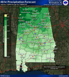
In yesterday’s briefing, I stated two rounds of storms were possible. The bulk of the first round has remained north of Alabama this morning. Scattered to numerous showers and a few storms are still possible this morning, mainly near and north of the Tennessee River. These storms are expected to remain below severe levels.
The second and more potent round of storms will enter the northern portion of the state as a line this afternoon and move southeastward through early Tuesday morning. Damaging wind gusts and heavy rainfall with localized flooding are the main threats. In addition, there will be enough wind shear for the potential of a couple of tornadoes as well. The storms will be weakening after they move south of I-20.
It should be noted that due to saturated soil conditions, trees could be downed by winds of less than 60 mph today and this evening.
Scattered to numerous showers and thunderstorms are forecast for much of the state from Tuesday through Friday, mainly during the afternoons and evenings. A few storms each day could produce winds of 40-60 mph.


