
CLANTON – Sunday, 7:00 am, April 26, 2026
As of 630 am, a cluster of thunderstorms in central MS is moving southeastward and may produce wind gusts from 40-50 mph in far southwestern AL between 8 am and 12 pm.
An area of thunderstorms with heavy rainfall will move into the far northern portions of the state after 10 pm Monday and continue southward into Tuesday morning, weakening once reaching I-20. A few wind gusts from 40-60 mph and very heavy rainfall are possible north of I-20.
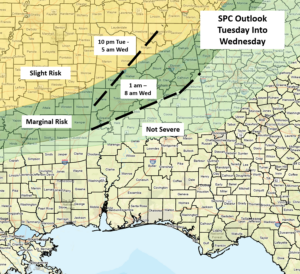
Yet another round of thunderstorms with heavy rainfall and potential severe weather will occur from Tuesday evening into Wednesday morning, as a cluster of storms moves southward out of the Tennessee Valley. Damaging straight-line wind gusts and very heavy rainfall are the main threats, once again near and north of I-20.
Although not continuous, additional upper-level systems may bring periods of heavy rainfall and some potential for severe weather from next Thursday through the weekend.
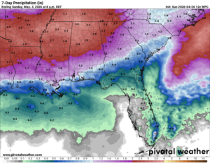
Even though beneficial rainfall will occur, total rainfall amounts through next Sunday morning will be 3-5 inches across the northern half of the state, with 1-3 inches over the southern half. As always, locally higher amounts will occur with stronger storms. Flooding may become an issue in some areas, especially by the middle of next week.


