
CLANTON – Wednesday, 6:00 am, April 22, 2026
Models continue to indicate a series of upper-level disturbances will bring much-needed rainfall to the state Friday through early Tuesday.
The first disturbance will bring showers and thunderstorms to the western portions of Alabama on Friday afternoon or evening, spreading across the entire state Saturday morning. A few storms may produce wind gusts from 40-60 mph and hail to the size of quarters north of I-59, but widespread severe weather will not occur.
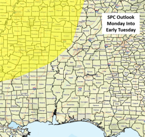
A stronger system will occur Monday afternoon into Tuesday. This has the potential to produce all types of severe weather, and the SPC still has a level 2 of 5 risk but has trimmed back the outlook to areas north of I-20 and west of I-65. Models remain poorly aligned, so expect additional changes to the outlook and timing in later updates.
Also, this is the SPC extended forecast, so Marginal Risk areas are not included. Monday is April 27th. Just in case you are wondering, this is NOT, I repeat NOT, the same setup as April 27, 2011.
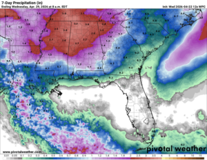
Total rainfall amounts through Tuesday will generally be 2-3 inches across the northern half of Alabama, with 1-2 inches across the southern half. Of course, there will likely be areas where higher amounts occur due to stronger storms.


