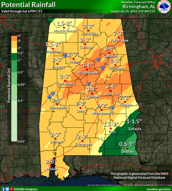
CLANTON, Ala. – Radar estimates that widespread 2-4 inches with isolated spots over five inches fell through 5 am near and west of I-65, with 1-3 inches east of I-65.
Bands of rain and thunderstorms, although not continuous, will occur through Saturday afternoon. An additional 2-4 inches is forecast at many locations with up to two inches in far southeastern Alabama.
Flooding of roads, creeks and other areas are possible. Be careful while driving, especially at night when you can’t tell the depth of water on the road. It takes much less water on the road than you think to make your car lose contact with the road. If the water is moving, you could easily be swept off the road.
In addition, there is now a Marginal Severe Risk for the entire state as a line of thunderstorms will enter the northwestern sections late this morning, move southeastward and exit the southeastern sections this evening. A few damaging wind gusts and possibly a tornado or two are possible. However, widespread severe weather will not occur.
Although more rain and thunderstorms will occur Friday, the severe threat will diminish and no severe storms are forecast at this time.
A stronger upper level disturbance will bring a higher severe threat as another line of strong to severe thunderstorms will move across the state from mid-morning Saturday through the afternoon. Damaging wind gusts, tornadoes and very heavy rain will all be possible.
Dry conditions will finally arrive by Sunday and continue through most of next week.


