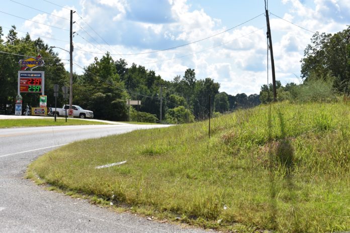
LOGAN, Ala. – After the most recent accident at the U.S. Highway 278/County Road 831 intersection in west Cullman County, several area residents contacted the Alabama Department of Transportation (ALDOT) to ask for safety measures such as a traffic light.
“Thank you for contacting us to voice your concern about the intersection of U.S. 278 and County Road 831. We are aware of the crashes that recently occurred and have been reviewing the intersection and the limited sight distance to the west.
“In 2014, following a previous fatal crash (which occurred at a nearby business entrance, not the intersection), we conducted an analysis to determine whether the intersection met standards for installation of a traffic signal, but a signal was not warranted based on traffic volumes and crash history. A signal would still not be warranted today.
“While crashes at this intersection are not as common as many believe them to be, we have seen an increase in the last two to three years. There has been little change in traffic volume or other factors that might explain a rise in crashes. We’ll continue to monitor the intersection and investigate further, including obtaining the results of the law enforcement investigations into these most recent crashes.”
The Tribune sent its own request to Burkett July 30 for information on traffic flow averages and the number of wrecks at the intersection in the last three years.
On the following day, Burkett replied:
“I want to reassure the public that we are looking into this. The intersection does not meet federal standards for a traffic signal, but we are still gathering information and working to identify potential options to improve safety. Unfortunately, I can’t release crash data, but I will provide you the traffic count.”
Follow-up statement urges motorists to pay attention to existing safety measures
On Thursday, Aug. 1, The Tribune received this follow-up statement:
“Traffic on U.S. 278 at this location is about 7,000 vehicles a day. That includes both directions over a 24-hour period.
“Standards for signalization are set by the Federal Highway Administration, and are in place to prevent signals that might negatively impact intersection safety. Even when warranted, traffic signals often increase the number of crashes at an intersection. With an isolated traffic signal in a rural area, side-angle crashes due to red light running are always a concern, and rear-end crashes (the type of crashes we see rise the most with a signal) at high speeds are also a concern.
“Understanding that this intersection does not meet federal warrants for a signal, we are looking at it to determine what safety improvements we can make.
“We’ve heard a number of concerns and comments from motorists over the past couple of weeks. We’re grateful for the personal experiences, observations and suggestions they shared with us to help us see the situation through their eyes. I want to reassure them that we take this very seriously, and we are working to explore options and find a solution.
“There is a flasher at this intersection and advisory speeds posted on the approaches on U.S. 278. It is apparent that some motorists are already ignoring the traffic control devices in place and not reducing their speed. I would like to plead with those motorists to be mindful of their speed and take into account that there are others trying to enter the roadway who may have difficulty seeing.
The U.S. Highway 278/County Road 831 intersection
At the intersection of the two roads and for some distance on either side, High. 278 is a two-lane east-west road, though a passing lane ends to the east of the intersection, on the westbound side approaching the intersection. County Road 831 is a two-lane north-south road.
The regulatory speed limit (posted on white signs) on 278 is 55 mph through the area, while on approaches to the intersection an advisory speed limit (posted on yellow signs) of 45 mph is posted, making that location an “advisory speed zone.” The advisory signs include an indication of a four-way intersection and the advised speed limit.
According to ALDOT’s 2015 Alabama Speed Management Manual:
Engineering judgment or traffic studies sometimes show the maximum legal speeds or posted regulatory speed limits are no longer applicable when certain conditions exist. In the presence of such conditions, advisory speed zones with speed plaques should be established through the use of proper signage to warn drivers of the recommended, maximum, safe, comfortable speed that conditions allow. The advisory zone may be a location within a regulatory speed zone requiring speed advisory signs, which the current MUTCD [Manual on Uniform Traffic Control Devices] shows as typical black lettering on yellow background.
and
There are situations which the posted speed limit exceeds the critical design speed. This is a situation for when advisory speed limits should be posted. Advisory speeds are typically recommended for curves, intersections, or other conditions that would require motorists to adjust their speed to less than the posted speed limit.
According to ALDOT’s 2015 Alabama Speed Management Manual, previous crash data is often used in the creation and regulation of advisory speed zones. Traveling above the advisory speed limit is not necessarily illegal but doing so can increase a driver’s liability in the event of an accident.
At the intersection, traffic flow on 278 is unhindered, except for the advisory speed signs and flashing yellow caution lights over the center of the intersection- known as an intersection control beacon, allowing drivers on 278 the right of way but warning them to watch for traffic from the side road.
Code of Alabama title 32 reads: Flashing yellow (caution signal). When a yellow lens is illuminated with rapid intermittent flashes, drivers of vehicles may proceed through the intersection or past such signal only with caution.
Traffic flow on 831 is regulated on both sides by standard STOP signs and red lights on the four-way intersection control beacon; both have the same legal effect of requiring drivers to stop. The STOP sign on the north side is placed close to the intersection, while the sign on the south side is set back from the intersection due to the intersection’s geometry. STOP bars (wide white lines across the approach lane, signaling where cars are to stop) are placed on both sides of the intersection, several feet back from the lanes of 278 coming through the intersection. Signs a short distance from the intersection on both sides alert drivers to the stop ahead, and sets of rumble strips on each side warn drivers to slow down. The posted speed limit at this point on 831 is 40 miles per hour.
About the red flashing signal, Alabama Law Code title 32 reads:
Flashing red (stop signal). When a red lens is illuminated with rapid intermittent flashes, drivers of vehicles shall stop at a clearly marked stop line, but if none, before entering the crosswalk on the near side of the intersection, or if none, then at the point nearest the intersecting roadway where the driver has a view of approaching traffic on the intersecting roadway before entering the intersection, and the right to proceed shall be subject to the rules applicable after making a stop at a stop sign.
First-hand: Tribune reporter W. C. Mann at the intersection
On Monday afternoon of this week, between 3:30 and 4 p.m. (not a particularly busy time on the road), I spent about 20 minutes at the intersection of 278 and 831, driving through the intersection multiple times from all directions, just to see what I could find. Following are my observations while driving on Highway 278:
- Traveling at 55 miles per hour, I was tailgated in both directions, on every pass. When I slowed down to 45 miles per hour in the advisory zone, cars crowded me even more, and the faces of drivers in my rearview mirror were not happy! Based on my observations, some drivers are accustomed to driving this section of 278 at high rates of speed, exceeding not only the advised speed but the regulation speed, as well. One local resident I spoke to after my drive-through said, “They think it’s the interstate.”
- Amid the jumble of wires and cables crossing over the intersection from every direction, the black intersection control beacon was not particularly visible. At night, though, I believe the lights would be seen easily.
- Visibility of the intersection and side road are fairly good when approaching from the east (Cullman side). When approaching from the west, though, I had to climb a rise, limiting my ability to see the side road in both directions until I was almost at the intersection; additionally, a grass-covered hump on the northwest side of the intersection interfered with my view of the side road to the north.
On County Road 831, I observed:
- Rumble strips and STOP bars are several years old and degraded. The rumble strips just are not all that “rumbly,” and the bars are faded. They are all still useful but could function better if refurbished.
- Approaching from the south, visibility was good to the right/east (toward Cullman), but limited to the left/west by the drop-off of Highway 278. A homemade sign on the STOP sign post advises, “Look left last, cross quickly.” One person reported previously that signs along the edge of the road and cars parked in the fueling area of the Sunoco gas station on the southwest side of the intersection hindered drivers’ views from this point, but I did not encounter these issues. An observer confirmed that some signs were removed recently and, at least on this day, I did not see vehicles parked at the station in a way that hindered my view.
- For me, the most dangerous spot in the intersection was the southbound approach on 831. With my car’s front end behind the painted STOP bar, visibility to the left/east was good, but my view looking to the right/west was of a grassy hump coming out from the yard on the northwest side of the intersection and reaching almost to the intersection. Even when I pulled my car forward, putting the front end just short of the edge of 278’s westbound lane, the combination of the hump and the drop-off of 278 to the west made oncoming traffic invisible until it was very close to the intersection. A homemade sign on the STOP sign post warned, “Look right last, cross quickly.”
Almost a statistic
My last pass through the intersection was southbound down 831 to the intersection, then left onto 278 to return to Cullman. I stopped behind the STOP bar with my blinker on and looked to the left/east, and the road was clear. I looked to the right and saw a grassy hump. Pulling forward to the edge of the highway, the left was still clear and the little more I could see around the hump to the right appeared clear. I glanced ahead to a driver stopped across the road and waving me on to turn before he crossed, and then started to accelerate out into the intersection.
As I began to roll, that homemade sign crossed my mind, and I did, just in time to see three cars come over the rise “bumper to bumper,” moving fast and shooting through the intersection a few feet in front of my car. I cannot attest to the speed at which they were traveling, but I am comfortable saying that it was not 45 miles per hour. And to the person who made those signs, well done!
What can be done? Standard Federal guidelines for dangerous intersections
Some statistical studies have shown that four-way traffic signals or STOP signs may actually increase the number of collisions, especially rear end collisions, at some rural intersections, but the 2009 U.S. Department of Transportation Federal Highway Administration (FHWA) publication “Low-Cost Safety Enhancements for Stop-Controlled and Signalized Intersections” offers other options for improving safety at intersections with higher accident rates.
At intersections with a major road and stop signs on a minor side road, listed low-cost safety countermeasures include:
- Doubled up (left and right), oversize advance intersection warning signs, with street name sign plaques, on the through road (278)
- Doubled up (left and right), oversize advance “Stop Ahead” intersection warning signs; doubled up (left and right), oversize STOP signs on the side road (831)
- Installation of a minimum 6-foot-wide raised splitter island on the stop approach of the side road (if no pavement widening is required.)
- Properly placed STOP bars on the side road
- Removal of foliage or parking that obstructs view
These improvements are recommended for rural intersections that have seen four to five crashes in a five-year period and are expected to reduce crashes by up to 40%.
Supplemental countermeasures (those with higher cost) for intersections with demonstrated higher rates of crashes include:
- Installation of a minimum 6-foot-wide raised splitter island on stop approach (831) which requires pavement widening. Recommended where ten crashes have occurred in five years.
- Either a) flashing solar-powered LED beacons on advance intersection warning signs and STOP signs or b) flashing overhead intersection beacons (installed). Recommended where eight to ten crashes have occurred in five years.
- Dynamic warning sign (sign with flashing lights) to advise through traffic (278) that a stopped vehicle is present and may enter the intersection. Recommended where 10-20 crashes have occurred in five years.
- Transverse rumble strips (installed) across the stop approach (831) lanes in rural areas where noise is not a concern and running STOP signs is a problem. Use “Stop Ahead” pavement markings if noise is a concern. Recommended where three crashes involving running the STOP sign have occurred in five years.
- Dynamic warning sign to advise high-speed approach traffic that a stopped condition is ahead; use this countermeasure when vehicles running the STOP sign is a problem. Recommended where five crashes involving running the STOP sign have occurred in five years.
The publication advises, “The entire set of basic signing and marking countermeasures should be the primary improvement considered at stop-controlled intersections with a high frequency of crashes.”
Included in the publication are suggestions for slowing down traffic on the through approach (278) when wrecks tend to involve excessive speed.
Low-cost countermeasures include:
- Lane-narrowing by means of rumble strips along the edges of the lane; or raised pavement markers where rumble strips cannot be used.
- Dynamic warning signs on the approaches telling drivers to slow down.
- Peripheral transverse pavement markings at a spacing of four markings per second.
- Slow or speed limit pavement marking legends highlighted within a gray or black colored box on the pavement and supplemented with advance intersection warning signs with advisory speed plates.
- High-friction surface applied to the approaches (approximately 300 feet in advance) and through the intersection.
Each of these would be considered for a rural intersection that has seen five crashes in the last five years.
The 2009 publication concludes:
A number of low-cost intersection countermeasures have been identified that are effective in reducing future crashes. Because the countermeasures are relatively low cost, they can be deployed at a substantial number of intersections with high numbers of crashes. The result of such a deployment can reduce statewide levels of intersection crashes and fatalities.
What else can be done? Innovative/experimental solutions
One solution, considered a novelty in the U.S. but typical in Great Britain, is the creation of a roundabout: a circular or oval feature with a large island in the center. No left turns are permitted; all vehicles go to the right upon entering and circle the island until they reach their intended exit point. A standard four-way intersection has 32 “points of conflict,” or spots where vehicles can collide, while a roundabout has only eight. A big problem with this solution, though, is its size: roundabouts are significantly wider than standard four-way intersections, and conversion would require the state to purchase or condemn properties immediately adjacent to the intersection.
Another solution, unveiled in various forms in 2017, uses sensors at intersections which send real-time alerts to approaching motorists about conditions in the intersection via devices installed in cars, or via a smartphone app. The technology is still experimental, and would only work in cars equipped with receivers, or for drivers with the app installed on their phones and activated as they approached the intersection. Both of these programs are still in testing and are primarily intended for use in cities and would be expensive to use at this point in their development.
A promising program which, in one form, has been in use in Minnesota for several years under the name Rural Intersection Conflict Warning System (RICWS), uses sensors located at certain distances from rural intersections to alert drivers on the side road (831) that traffic is approaching on the main road (278). When a vehicle on the main road trips one of the sensors, a combination of flashing lights and digital signage is activated to warn side road drivers of oncoming traffic. A similar combination of devices can also be used to alert drivers on the main road to watch for traffic approaching from the side road.
Copyright 2019 Humble Roots, LLC. All Rights Reserved.


