










CULLMAN, Ala. – Gov. Kay Ivey declared a state of emergency for 40 Alabama counties Wednesday, Oct. 7, ahead of Tropical Storm Isaias, while forecasters warned that Cullman County could experience gusty winds and rain as the system moves inland this weekend.
Cullman County is not among the counties named in the announcement. Tuscaloosa County is included to the southwest, beyond Walker County, but none of Cullman County’s adjoining counties appears on the list.
The declaration took effect at 4 p.m. Wednesday and is scheduled to expire at 11:59 p.m. Oct. 14 unless changed by proclamation, according to the announcement.
“While we continue to monitor forecasts, we have to prepare now,” Ivey said.
“As we approach the weekend and any travel plans, make sure you have reliable information as conditions develop. While I hope for minimal impacts, we must take preparations seriously,” she said.
Alabama Emergency Management Agency meteorologist Jim Stefkovich’s 3 p.m. Wednesday update reported hurricane and storm surge watches for Mobile and Baldwin counties.
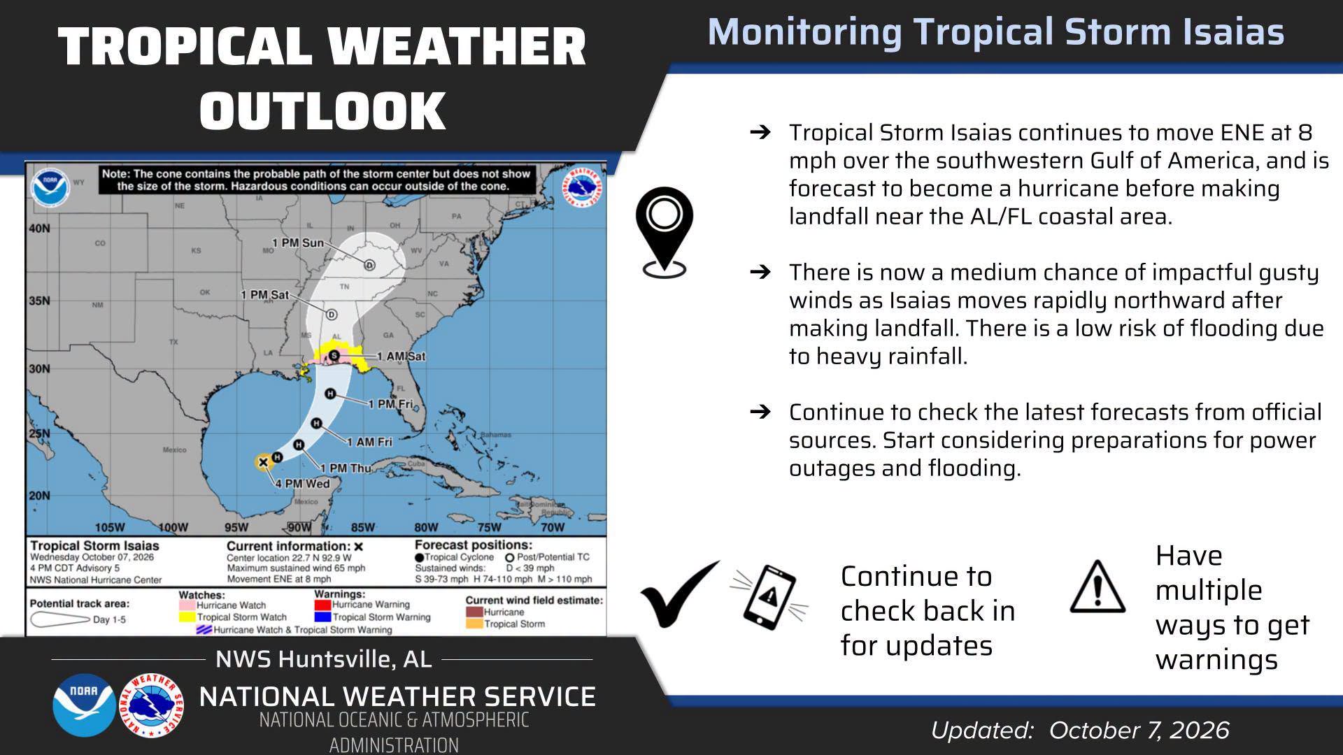
Isaias was expected to strengthen into a hurricane Thursday, with landfall anticipated Friday night or early Saturday along the northern Gulf Coast.
At 1 p.m. Wednesday, the National Hurricane Center reported maximum sustained winds of 50 mph. Its forecast called for the storm to approach the northern Gulf Coast Friday.
For Cullman County, the concern extends beyond the coastal landfall.
The National Weather Service in Huntsville’s Wednesday afternoon forecast discussion described a medium chance of impactful gusty winds and a low risk of flooding in the Tennessee Valley as Isaias moves rapidly northward Saturday and Saturday night.
Forecasters said outer rainbands could arrive Friday night, followed by a potentially windy and rainy Saturday into Saturday night. Wind gusts of at least 30-40 mph were possible in the region, especially across higher terrain.
Alabama EMA’s afternoon update forecast up to 3 inches of rain north of Interstate 20 through Sunday evening, with locally higher amounts possible. Cullman County is north of that corridor. Those figures describe a broader region and are not a guaranteed total for every community.
NWS Huntsville urged residents to begin considering preparations for power outages and flooding. For local households, that means planning for possible interruptions to electricity and staying alert for flooding in vulnerable areas.
The tornado outlook also depends on the storm’s eventual track. NWS Huntsville said a track farther east could keep the stronger storms and tropical tornado threat south and east of the Tennessee Valley. A track farther west could bring more rain and at least a low tornado threat to the region.
At the time of its 2:36 p.m. Wednesday discussion, NWS Huntsville listed no watches, warnings or advisories for its Alabama forecast area. Residents should continue checking for updates as the storm approaches.
Residents traveling to the coast face a more serious set of potential hazards. Alabama EMA forecast possible storm surge of 5-7 feet along the coast and Mobile Bay.
The National Hurricane Center also warned of dangerous surf and rip currents along the Gulf Coast.
Alabama EMA stressed that the forecast cone shows the expected path of the storm’s center, while impacts can extend well outside it.
Residents should have multiple ways to receive weather warnings, review their plans for a power outage and follow instructions from emergency officials. Drivers should never travel through flooded roads.
Conditions are expected to improve Sunday, with Alabama EMA forecasting an end to rain and wind impacts by Sunday evening. The timing and severity of local impacts remain dependent on the storm’s track and strength.