
CLANTON – Friday, 7:30 am, April 24, 2026
A line of thunderstorms will move into western Alabama this evening and rapidly weaken once reaching the I-65 region between 12 am and 6 am. A few storms west of I-65 could produce wind gusts from 40-60 mph. Redevelopment of showers and thunderstorms is expected Saturday afternoon and evening. A few storms could produce wind gusts from 35-50 mph.
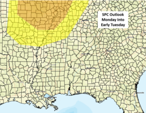
After a relatively quiet Sunday with just a few showers and thunderstorms, a stronger system will bring more widespread activity to the state from Monday evening into Tuesday. The SPC continues to adjust the forecast for severe storms farther away from the state, but there could still be isolated severe storms and very heavy rainfall generally north of I-20.
A stalled frontal boundary and additional upper-level disturbances will move across the southeastern US next Wednesday through Saturday. Scattered to numerous showers and thunderstorms are possible each day.
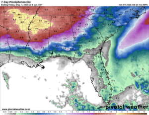
Total rainfall amounts by early Friday will generally be 2-4 inches across the northern half of Alabama, with 1-2 inches across the southern half. There will likely be areas where higher totals occur due to stronger storms. Note in the rainfall total graphic below that 4-6 inch amounts are forecast in Mississippi. These higher amounts could easily shift eastward in later updates.
Regardless, flooding may become an issue in some areas of Alabama during the middle to latter part of next week.


