
CLANTON, Ala. – Sunday, March 15, 2026, 7 a.m.
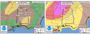
…Areas east of I-65 and south of I-85 have been upgraded to Enhanced Risk…
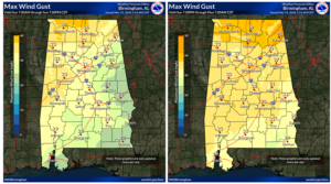
Non-thunderstorm winds will be on the increase this afternoon and evening ahead of a line of severe thunderstorms. Sustained winds will be 10-20 mph with gusts from 20-30 mph south of I-20 and 25-35 north of I-20. A few gusts could reach 40 mph in the higher elevations of north Alabama.
The fast-moving line of severe thunderstorms will enter the northwestern sections this evening and exit the southeastern portions by early Monday.
Due to the fast movement of the line, momentum winds brought down to the surface from the thunderstorms will likely result in scattered to widespread wind damage, especially across the northern half of the state, where gusts could be 70+ mph. There could be embedded tornadoes as well within the line, including the potential for EF2+ (strong tornadoes).
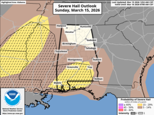
In addition, there is growing concern that for areas east of I-65 and south of I-85 (east of an Atmore – Montgomery – Auburn line, supercells could develop ahead of the line, or the line itself could become more broken and super cellular in nature. Regardless, there is potential for long-track, strong tornadoes, very large hail, and damaging straight-line winds.
This is the type of event where Severe Thunderstorm Warnings should be treated like Tornado Warnings. Since this will mainly be a nighttime event, make sure you have at least two methods to receive severe weather warnings, one of which is NOT an outdoor warning siren.
If a warning is issued, get to the lowest floor in a sturdy building, putting as many walls between you and the outside as possible. Finally, ensure you and those with you are wearing helmets (sports, biking, work) and sturdy footwear. You don’t want to walk around barefoot in case damage occurs.
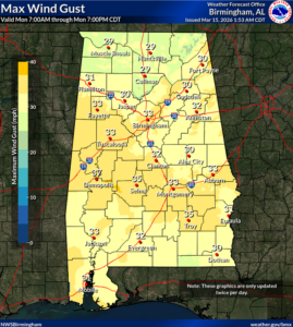
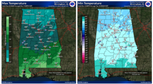
Temperatures will be dropping rapidly during the day on Monday, and statewide winds behind the front will contain gusts from 20-35 mph through the afternoon. In addition, some snow showers and/or sleet may occur Monday morning, possibly as far south as a Livingston – Montgomery – Auburn line. No winter impacts are expected.
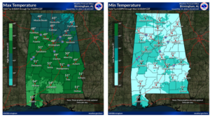
A hard freeze will occur Tuesday morning with low temperatures from the lower 20s north to middle 30s near the coast. Highs on Tuesday will be from the lower 40s north to middle 50s south. Lows Wednesday morning will again drop below freezing in many locations with middle 20s to middle 30s. A warm-up will begin on Wednesday.


