
CLANTON – Friday, 8:00 am, March 13, 2026
A potent upper-level system and associated strong cold front will push a fast-moving line of thunderstorms through the state Sunday evening through Monday morning. Damaging straight-line winds and a few tornadoes are the main threats. In addition, some snow flurries or snow showers are possible north of I-20 Monday morning as very cold air ushers into the state.
The highest threat of severe weather is currently forecast north of I-59, but this and timing are likely to change in later outlooks, as models are not yet fully in agreement.
In addition, due to the very fast movement of the line, momentum winds brought down to the surface from the thunderstorms could result in pockets of wind damage (i.e., more widespread), especially across the Slight Risk area.
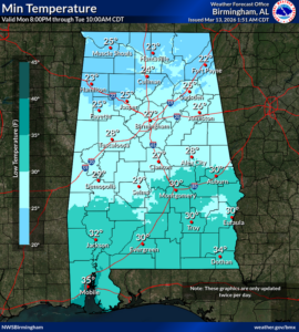
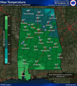
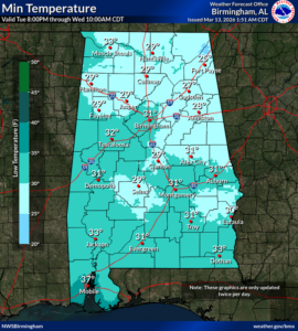
A hard freeze will occur Tuesday morning with low temperatures from the lower 20s north to middle 30s near the coast. Highs on Tuesday will be from the lower 40s north to middle 50s south. Lows Wednesday morning will again drop below freezing in many locations with middle 20s north to middle 30s south. A warm-up will begin on Wednesday.


