CLANTON, Ala. – Thursday 7 a.m., Jan. 22, 2026
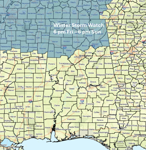
A Winter Storm Watch is in effect north of I-20 from 6 p.m. Friday through 6 p.m. Sunday.
Scattered to numerous rain showers will continue across the state this morning, ending during the afternoon.
Precipitation is now forecast to re-enter the northwestern portions of the state between 2-6 a.m. Saturday, spreading across the northern half during the afternoon and all of Alabama Saturday night into Sunday. The precipitation will end Sunday evening. This system will produce widespread 1-3 inch “liquid” totals across the northern half and an inch or less across the southern half.
The good is that models continue to push warmer air north of I-20. However, freezing temperatures will still occur north of a Vernon – Cullman – Centre (Lake Weiss) line with freezing rain and/or sleet through Saturday morning. It should be noted that temperatures south of this line to I-20 will only be 2-4 degrees above 32. A very close call of rain versus freezing rain and this could change.
Except for the far northern sections of the state, temperatures are forecast to rise above freezing Saturday afternoon and remain so through Sunday morning.
Total ice amounts through 6 am Sunday could reach 0.25-0.5 in both the far northwestern and northeastern sections of the state. However, very cold air will begin moving into the state by Sunday afternoon, and a transition to light freezing rain and/or snow will likely occur from Sunday afternoon until the precipitation ends Sunday evening.

Total freezing rain amounts after 6 a.m. Sunday are only expected to be below 0.1 inch and snowfall from a trace to 0.25 inch mainly across both the northern and western halves of Alabama.
This changeover could still cause some travel impacts, and standing water on roadways could freeze. I would not be surprised to see the NWS issue Winter Weather Advisories south of I-20 in later updates if this trend continues.


Temperatures by Monday morning will be in the teens north and 20s most elsewhere. Highs will be very cold with 20s north to mid 40s south. Lows Tuesday morning will be in the single digits north with teens and 20s elsewhere. Highs on Tuesday will be in the middle 30s north the lower 50s south.


