
By Jim Stefkovich, Meteorologist, Alabama Emergency Management Agency
CLANTON – Tuesday, 6:30 am, June 16, 2026
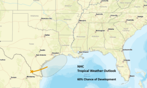
An area of low pressure is expected to emerge over the western Gulf today, with a 60% chance of a short-lived tropical storm forming before moving ashore in Louisiana on Thursday. Tropical storm watches or warnings may be needed later today.
This system will produce extensive moisture with numerous showers and thunderstorms across Alabama today through Friday. Heavy rainfall will be the main threat each day, with potential for flooding, especially Thursday into Friday.
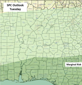
In addition, a couple of damaging wind gusts and perhaps a tornado or two are possible anytime today for the far southern sections of the state. On Thursday, the entire state is under a Marginal Risk due to the proximity of the tropical low-pressure center. A few damaging wind gusts and a couple of tornadoes will be possible.
Total rainfall amounts through Friday night are forecast to be 1-4 inches north of I-20 and 4-8 inches south of I-20. There could be areas with 10+ inches and significant flooding. A return to scattered mainly afternoon and evening showers and storms is forecast both Saturday and Sunday.


