
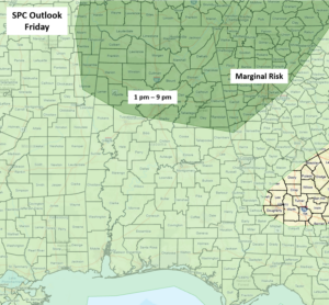
CLANTON –Friday, 7:30 am, July 3, 2026
Scattered thunderstorms are forecast to develop mainly near and north of I-20 today. A few storms could produce wind gusts up to 60 mph, small hail, frequent lightning, and heavy rainfall between 1 pm and 9 pm.
On Saturday, isolated to scattered showers and thunderstorms are forecast statewide, with scattered thunderstorms statewide from Sunday through at least next Wednesday. Although some activity may occur overnight, the bulk will be in the afternoon and evening.
A few storms each day could produce wind gusts from 40-60 mph, but widespread severe weather is not expected. Marginal Risk areas may occur for parts of the state through the weekend in later updates.
Since this is a holiday weekend with a lot of outdoor activity, make sure you remain weather aware. If you hear thunder, you are most likely within range of being struck by lightning. Don’t become a statistic! When thunder roars, go indoors.
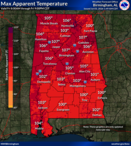
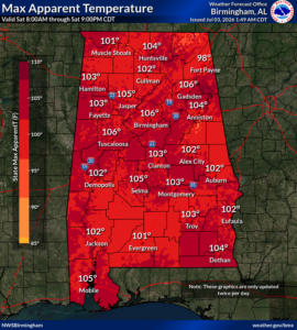
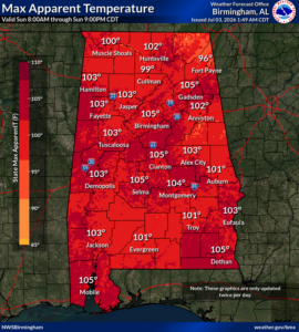
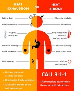
Hot and humid conditions will continue through at least next Tuesday, with highs mainly in the 90s and lows only reaching the middle 70s. Heat index values during the afternoons will be 100-109, and Heat Advisories will likely be extended past Saturday.
Drink plenty of fluids, stay in an air-conditioned room, stay out of the sun, and check up on relatives and neighbors. Children and pets should NEVER be left unattended in vehicles under any circumstances.


