
CLANTON – Friday, 1230 pm, May 22, 2026
Clusters of storms continue to occur early this afternoon from eastern Mississippi to central Alabama, with all moving east. This event is characterized by high shear but relatively low instability. As a result, a number of storms will rotate through the afternoon and into the evening, with the potential for brief tornadoes, damaging wind gusts, and torrential rainfall.
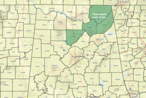
A Flood Watch is in effect for Cullman, Marshall, DeKalb, and Jackson counties until 10 Saturday.
Because of the potential increase of a tornado threat, the SPC may upgrade portions of the state to Slight Risk in later updates. At this point, widespread severe weather is still not expected. A decrease in both storm coverage and intensity is forecast between 10 pm and 2 am.
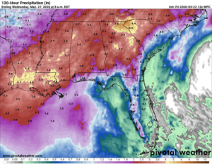
The wet pattern will continue not only through the Memorial Day weekend, but well into next week. This will bring much-needed and widespread rainfall with at least 2-4 inches through next Tuesday.
However, there will be a number of locations with 6+ inches by next week. The good news is that the rainfall will not be continuous, which should allow any flooded areas to subside day to day.
Finally, it’s important to remember that if you can hear thunder, you are likely within distance of being struck by lightning. If you are outdoors, make sure you get to a safe location until the storm passes.


