
CLANTON – Thursday, 8:00 am, February 26, 2026
A few bands of showers and thunderstorms will move slowly southward across the state today through Friday, affecting mainly the northern half through midnight and the southern half from midnight through Friday afternoon.
A few storms could produce hail to quarter size (primary threat), and wind gusts from 40-60 mph across parts of the northern and central sections. There is no tornado threat. The severe threat is also conditional on increasing instability late this morning through the evening. Instability may remain too low for any severe storm development today. Regardless, widespread severe weather will not occur.
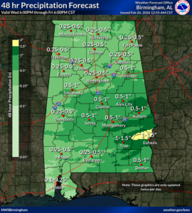
Total rainfall amounts will mainly be 1 inch or less. However, in some of the stronger storms, 2+ inches are possible in isolated locations, which may result in brief flooding.


