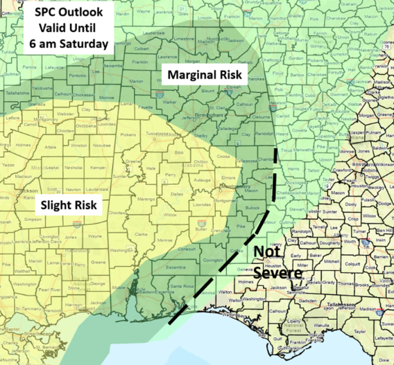
CLANTON, Ala. – There are two distinct weather threats today into Saturday. The first is heavy rainfall and the other is severe storms with damaging winds and tornado potential.
As of 6 a.m., rain has entered northwestern Alabama and will reach the rest of the western sections by mid-morning. Several waves of heavy rainfall will occur today through Saturday with widespread 2-4 inch totals, and some areas potentially receiving much more than 4 inches, resulting in flooding.


Concerning severe weather through Saturday the complicated forecast centers on a couple of items. The first being the placement of a boundary expected to become stationary later this afternoon into tonight somewhere across central Alabama south of I-20. Near and south of the boundary severe storm development is possible, with the highest chances through tonight west of I-65. Damaging wind gusts, hail and a few tornadoes are all possible.
Although there will likely be a break of severe weather this evening across the northern half of the state, wind shear will increase tonight aiding in potential severe storm redevelopment after midnight and lasting into Saturday morning.
For the southern half of Alabama, there is a much longer window for severe weather potential from later today into Saturday afternoon, albeit severe storms will not be continuous for the entire timing period. The exception will be the southeastern sections where severe weather not occur until late Saturday morning through the early evening.
After 6 a.m. Saturday, severe weather anywhere in the state will be isolated as the main upper-level support will have moved well away from our state.

Finally, continue to expect timing changes mainly based on boundary locations and amount of available instability later today into Saturday.
Make sure you can receive warnings from at least two sources, one of which is NOT an outdoor warning siren. Also, never drive into flooded roads, especially at night, as you can’t tell how deep the water is. It only takes 18 inches (or less) of standing water for your vehicle to lose contact with the road. If that water is moving quickly, you could easily be swept off the pavement.


