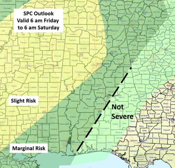
CLANTON, Ala. – Rain will begin entering the state tonight through Friday morning, leaving a frontal boundary somewhere across western/central Alabama by Friday afternoon. This boundary will be the focus for severe weather and very heavy rainfall through at least early Saturday. Of growing concern is that flooding rainfall exceeding 4 inches could occur near this boundary could exceed 4 inches by Saturday afternoon. Concerning severe weather, there is still uncertainty about how much instability will develop Friday afternoon and Friday night due to extensive cloud cover and rainfall. Lesser instability would dampen severe storm development (but not heavy rainfall). The NWS offices are monitoring to determine if Flood Watches will be needed in later updates.
Still, it appears some severe weather is possible mainly in the Slight Risk area from Friday afternoon into early Saturday. Damaging wind gusts, isolated hail and a few tornadoes are all possible. A surface cold front will then move through the state on Saturday morning through the afternoon. Although the main upper level support will have shifted far away from Alabama, there could still be a enough instability for a couple of damaging wind gusts and a tornado or two from Saturday morning through the afternoon. As a result, the SPC has introduced a Marginal Risk for most of the state. The severe threat will end in the southeastern sections around 8 p.m. Saturday.Make sure you can receive warnings from at least two sources, one of which is NOT an outdoor warning siren. Also, never drive into flooded roads, especially at night, as you can’t tell how deep the water is. It only takes 18 inches (or less) of standing water for your vehicle to lose contact with the road. If that water is moving quickly, you could easily be swept off the pavement.


