CLANTON, Ala. – Thursday, 1:15 pm, Dec. 18, 2025
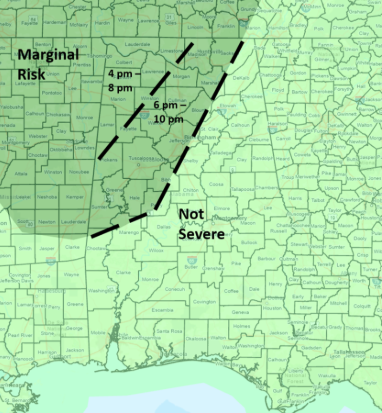
A broken to solid line of thunderstorms will enter northwestern Alabama around 4 pm, move southeastward throughout the evening, and exit the far southeastern sections before daybreak Friday.
Latest hi-resolution model data indicates enough instability and wind shear will exist from late afternoon into the evening hours west of a Livingston – Clanton – Birmingham – Scottsboro line for the SPC to introduce a Marginal Risk Area. A few wind gusts from 40-60 mph and a couple of tornadoes are possible. However, widespread severe weather will not occur.
The storms will weaken rapidly after 10 pm as they move east of I-65. Although not severe, a couple of storms could produce brief wind gusts from 30-40 mph east of I-65 and north of I-85 between 8 p.m.-midnight.
Total rainfall amounts will generally be 1 inch or less. High temperatures Friday will be in the 40s and 50s with lows Saturday morning from the 20s north to 30s elsewhere. Warmer temperatures will occur from Saturday through at least the middle of next week with highs generally in the 60s. Low temperatures Sunday morning will be in the 30s and 40s with 40s and 50s from Monday through at least next Wednesday.
Current models indicate little to no rainfall or severe weather from Saturday through at least the 28th. No white Christmas this year!


