
CLANTON, Ala. – Tuesday, 2 p.m., May 5, 2026
A cluster of storms will move across far northern Alabama tonight into early Wednesday morning. A couple of storms could produce wind gusts from 40-60 mph, mainly near and north of the Tennessee River from 12 am through 7 am.
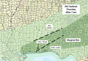
After a brief lull, clusters of showers and thunderstorms will again enter the far northern sections during Wednesday afternoon and move southward, reaching the I-20 corridor between 8 pm and 12 am Thursday and exiting the southern portions of the state by 2 pm Thursday. This is a slightly faster timeline than previous forecasts.
It appears supercells could develop both ahead of and within storm clusters, then weaken over the southern half of the state late Wednesday night or early Thursday morning. Very heavy rainfall, damaging straight-line winds, hail, and a few tornadoes are all possible, especially within both the Slight and Enhanced Risk areas. Across the southern half of Alabama, very heavy rainfall and a few damaging wind gusts are possible.
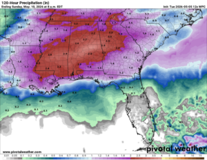
Total rainfall by Thursday evening will generally be 1-3 inches across the northern half of the state, with 0.5 – 2 inches in the southern half. Some spots could have 4+ inches in stronger storms, resulting in localized flooding.
Another upper-level disturbance will bring showers and thunderstorms mainly to the southern half of Alabama Friday into Saturday, producing an additional 1-2 inches of rainfall.


