
CLANTON – Sunday, 8:00 am, March 8, 2026
On Monday, an upper-level disturbance will produce showers and thunderstorms that will move from west to east across Alabama during the afternoon and evening hours. A few storms may produce very heavy rainfall, wind gusts from 40-60 mph, and large hail (golf ball or larger). Scattered showers and a few non-severe thunderstorms are possible north of I-20 on Tuesday.
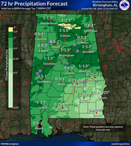
Total rainfall amounts from this morning through Tuesday afternoon will generally be 0.5-1.5 inches, with 0.5 inch or less east of I-65 and south of I-85.
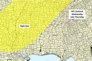
A potent upper-level system will drive a strong cold front through the state Wednesday night through Thursday morning. The latest SPC outlook now has areas near and north of I-59 in a Slight Risk, and additional changes to both locations and potential threats will continue to evolve over the next couple of days.
A line of strong to severe storms will enter the western sections of the state on Wednesday afternoon or evening and exit the southeastern portions on Thursday morning. In addition, a few supercells may develop ahead of the line of storms. Damaging wind gusts, hail, a few tornadoes, and very heavy rainfall will all be possible.


