
CLANTON – Friday, 8:00 am, February 13, 2026
A line of showers and thunderstorms will enter the western portions of the state after sunrise Sunday, move from west to east during the day, and exit the eastern portions by 6 pm.
A few damaging wind gusts and a couple of tornadoes will be possible, generally near and south of I-20. Behind the line, a few storms may redevelop during the afternoon, which could contain some hail.
This continues to look like a typical wintertime high shear (for rotating storms) but low instability event. Thus, widespread severe weather is not expected. However, if more instability develops than currently forecast, there could be an uptick in the number of severe storms. Even if this occurs, the chances for widespread severe weather are low.
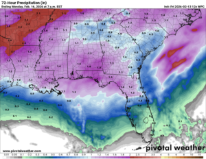
Total rainfall amounts will range from 0.5 to 1.5 inches.


