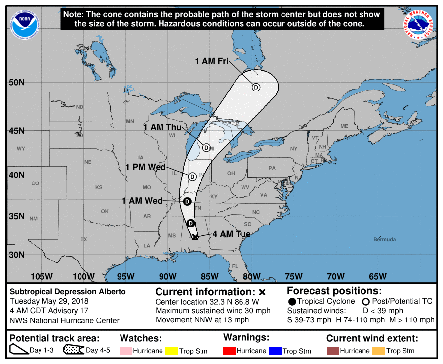
Alberto’s predicted path, as of early Tuesday morning (NOAA/National Weather Service)
CULLMAN – What does Subtropical Storm Alberto mean for north Alabama? Late Monday afternoon, The Tribune spoke to forecasters from the National Weather Service office in Huntsville who are tracking Alberto, to make sense of the various weather models being broadcast and to get a detailed look at what Cullman County might expect.
Alberto became the 2018 hurricane season’s first named storm around midday last Friday, a week ahead of the official start of the season, as a subtropical storm. A subtropical storm is a hybrid weather event, combining the warm core of a tropical storm with the cooler upper-level temperatures of a low-pressure system. Such storms are less likely than conventional tropical storms to become hurricanes. Powerful winds around 30,000 feet drew warm moisture up into the storm over the weekend, however, allowing it to strengthen and become more organized as it moved northwest through the Gulf of Mexico.
With a more conventional structure and plenty of warm, moist air coming into the system, Alberto looked like it could develop into a hurricane before making landfall. On Sunday, though, dry air began to be absorbed into the system, lessening that likelihood. From sustained winds of 65 mph late Sunday evening, speeds were running 50-60 mph by Monday afternoon. As it made landfall at Laguna Beach late in the afternoon, wind speeds were around 45 mph. Alberto will weaken into a tropical depression as it moves north through the state.
Early models had the storm’s center passing west of Birmingham and Cullman, placing the entire county on the east side where rainfall is typically the highest. Later models differed, with at least one showing an estimated path passing between East Point and Berlin late Tuesday morning. NWS Huntsville staff placed the model closer to I-65, and a late afternoon revised model moved the track closer to its earlier predicted route west of Colony, Dodge City and West Point.
While the storm's center might be mapped along a narrow track, residents are encouraged to remember that the system's range of effects can be hundreds of miles wide. Alberto is expected to affect all of Alabama, especially the eastern half.
The threat to Cullman County
All of north Alabama will see rain and wind with a small chance of isolated thunderstorms and even a possible tornado over the next two days, but if the storm follows the track established Monday afternoon, parts of the county west of the storm track should have a minimal chance of dangerous weather. Parts east of the storm track face a higher rainfall threat from 2 to 3 inches, and some models warn that up to 6 inches could fall in some areas.
Wind is not expected to be a major danger, but flash floods are a possibility from early Tuesday morning through Wednesday, especially in the eastern parts of the county. The highest risk should pass Tuesday afternoon. A chance of isolated thunderstorms, including strong storms that could produce a tornado, will exist through Thursday across most of eastern north Alabama, including eastern Cullman County.
The counties of Lauderdale, Colbert, Franklin (Alabama), Lawrence, Limestone, Madison, Morgan, Marshall, Jackson, DeKalb, Cullman, Moore, Lincoln and Franklin (Tennessee) are under a Flash Flood Watch from 7 a.m. Tuesday to 7 a.m. Wednesday.
For the very latest, visit the National Weather Service website at www.weather.gov.
Copyright 2018 Humble Roots, LLC. All Rights Reserved.


